| Baccalieu Trail Heritage Corporation |

|
|
|||
 |
|
There is little evidence of human activity in the area around the original plantation site from sometime around 1700 until the second half of the 18th century. However, recent documentary research has shown that the land on which the plantation was established was not abandoned. Indeed, we can now trace land ownership at the site from the 17th century to the present day. On March 4, 1674 James Hill, a planter at Cupids Cove, wrote his last will and testement leaving "all my goods within and without the ...house at Cupits Cove to Thomas Butler now of Porta Grave [and] his assignees" and appointing Butler his executor. A number of early 17th century documents refer to a Master Hill living in Cupids, the earliest dating to 1616. For example, in a letter written in St. Johns on 8 July 1623, Richard Newell mentions acquiring salt cod "from Master Hill's at Cupids Cove". It seems likely Hill was the the agent sent out by the Newfoundland Company to run their business and that he stayed on after the company ceased to operate. D'Iberville's raid over the winter of 1696/97 had a devastating effect on Newfoundland's English Shore but settlers soon began to return. A list of people "designed to stay" in Newfoundland compiled in 1698, just one year after the raid, lists a planter and his servant at Cupids Cove; a list of planters compiled the following year lists five people living there; and a list from 1701 records a planter with his wife and child living in Cupids. On 11 February 1737, sixty-three years after James Hill wrote his will at Cupids Cove, the widow Mary Pynn, who was living in "Muskitta Cove in the Bay of Conception in Newfoundland" at the time, signed a land grant leaving "the Fishing Room and Meddow Gardens and Meddow Grounds being on the South side of Portograve, commonly called Cupits Cove [and] formerly being in the possession of Master James Hill" to her son Henry. Mary also states that James Hill "lawfully gave [the land] to me Mary Pynn senior". For Mary to claim to have inherited the land at Cupids "lawfully" from James Hill, she must have been one of Thomas Butler's assignees, most likely his daughter. Henry Pynn died in 1750 and, on 12 October, 1774, his widow, Anne, sold the property in Cupids to Harbour Grace merchant John Clements. We know from information contained in the "Conception Bay Plantation Book", compiled between 1804 and 1806, that the land purchased by Clements ran east along the harbour in Cupids for 654 ft from the West Brook to the east end of the Salt Water Pond. We now know that John Guy's first dwelling house was built on a terrace within the boundaries of this property roughly 260 ft. east of the West Brook. |
 |

 |
 |
 |
|
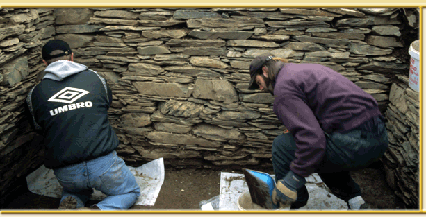
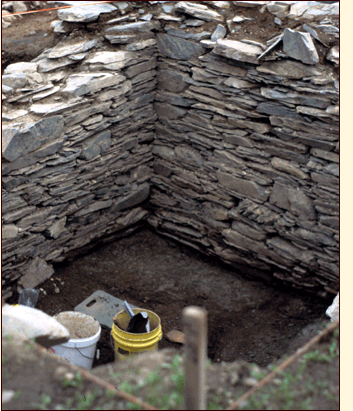
It seems that for much of the 18th century the main focus of human activity on the plantation shifted to the north and east of the original 1610 enclosure and that the area around the enclosure was used either as meadow land or to raise crops. Only a few artifacts that definitely can be dated to the early-to-mid-18th century have been found in the area of the enclosure. These include a copper-alloy shoe buckle and a number of fragments of English scratch-blue stoneware. We also know that sometime around 1800, the abandoned pit originally dug to hold the cellar inside John Guy's storehouse was filled in. John Clements died in 1802 and, on 27 September 1807, Cupids planter George Smith entered into an indenture with Clement's executor, George Lilly, to purchase the land for 100 pounds to be paid in five yearly installments. Less than six years later, on 25 May, 1813, Smith sold all the property except from a small section at the eastern end to Samuel Spracklin Jnr. for 70 pounds. It was probably around this time that Samuel built his house on the northern edge of the 1610 enclosure just 13 ft. north of John Guy's original dwelling house. Samuel's house was erected right on the line of the inner defensive wall and just where cannon fire had created a breach in the late 17th century. Inside his house was a 7 ft. deep stone-walled cellar built from stones recycled from that wall. The increase in human activity in this area after 1813 is attested to by literally thousands of artifacts including shards of creamware, pearlware and other refined earthenwares, fragments of 19th century bottle glass and 19th century clay tobacco pipe bowls and stems found in and around Samuel's house and in the 19th century deposits all over the site. After Samuel and his wife Mary's death, the house continued to be occupied for a number of years by their eldest son, Simon. A photo of the area taken shortly before 1910 shows the house still standing but by the early 1920s it had disappeared. We rediscovered and excavated the cellar from Samuel's house in 2000. In about 1847 Samuel's younger son, John, built the house and barn that still stand at the entrance to the site. John Spracklin's son, John Jnr., sold his share of the land, including the house and barn, on 22 June 1925. The section of the property inherited by Simon Spracklin, and where both John Guy and Samuel Spracklin had built their houses, passed to the Ford family sometime after Simon's daughter, Mary Charlotte married Elias Ford on 8 February, 1855. Ownership of the land later passed to the Whalen family when Mary Charlotte and Elias's daughter Priscilla married Caleb Whalen on 5, January 1892. Priscilla and Caleb's granddaughter (and Samuel Spracklin's great-great-granddaughter) Ruth Baker and her husband Garland still owned that piece of land and were using it as a summer home when we arrived and began digging there in 1995. Fifteen years later, in 2010, the area was declared a Provincial Historic Site. Images (left to right, top to bottom) 1. Excavating the cellar inside Samuel Spracklin's house built in 1813. |
 |
|||